


High weekend temperatures, strong erratic winds fan flames in northeastern BC
A cold front on Saturday evening, accompanied by strong gusty, erratic winds brought with it challenging conditions for BC Wildfire Service fire fighters as these conditions, coupled with continued warm weather, caused additional fire growth in the Peace River Regional District.
BCWS information officer Karley Derosiers anticipated these conditions in an update on Saturday, June 8, but noted that when winds died down in the evening, an increase in smoke would help limit fire behaviour.
“As long as it stays smoky, fire behaviour will continue to be low to moderate as the smoke helps to bring temperatures down, increasing humidity, it provides a bit of insultation from direct sunlight,” Derosiers said.
Monday, however, saw the smoke clear and winds pick up, which increased fire activity for two of the three biggest fires burning in the region this week.
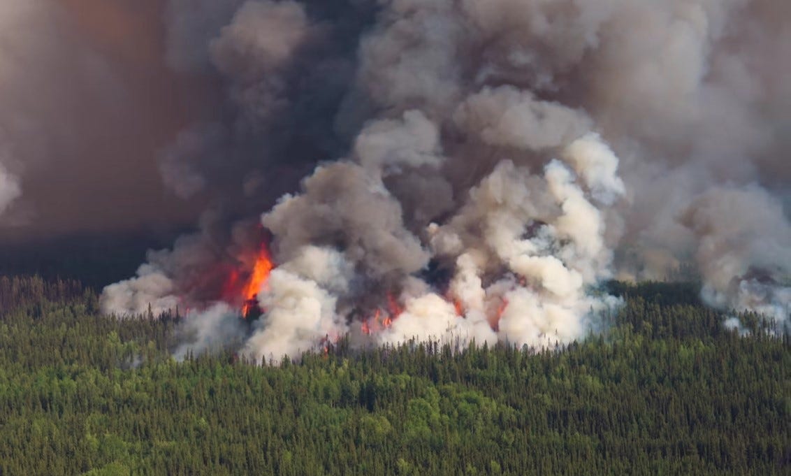
Last week, winds propelled the Kiskatinaw River Wildfire (G70422) towards the community of Kelly Lake, and over the border into Alberta on June 3. Crews from around the province and Alberta have joined together to fight this blaze, and Derosiers said that fire crews had been working on a containment line, hoping to do some ignition operations to remove available fuel from the fire perimeter on June 7.
“Pockets of spruce are the most volatile,” she said.
The fire continued to move closer to the community of Kelly Lake and according to the PRRD’s Emergency Operations Centre Director Mike Watkins claimed seven structures in Kelly Lake on June 9. However, Watkins didn’t think any inhabited residences had been impacted.
“We have to continue to stress that it’s a very dynamic situation and the BC Wildfire Service continues to conduct active suppression operations in the community,” said Watkins.
The evacuation alert area for the Kiskatinaw wildfire was expanded to the east of the evacuation order area in the evening of June 9, now includes all the Bearhole Lake Protected Area and a portion of Bearhole Lake Park.
The new Kiskatinaw River alert area is as follows:


Alert #6:
· From the junction of Weaver Rd and One Island Lake Rd, southwesterly and southerly following the western boundary of Evacuation Orders, from north to south, #4, #2, #1, #3, #5 to a point of intersection with Hwy 52E,
· West 13.8 km,
· North crossing Thunder Creek and Kiskatinaw River for 13.7 km,
· Northwesterly 16 km to a point of intersection with Hourglass Rd which is approximately 3.5 km due of west of Noel Rd,
· North 20.8 km to approximately Burial Creek,
· East 21.8 km to the Junction of Weaver Rd and One Island Lake Rd,
· This includes all of Bearhole Lake Protected Area and a portion of Bearhole Lake Park.
The Kiskatinaw River fire has now grown to 21,679 hectares and is classed as out of control.
In the North of the regional district, the Pocket Knife Creek wildfire (G80352) in the Buckinghorse and Sikanni Chief area is what Watkins describes as an expanding situation, seeing a dramatic increase in activity over the last 24-hours, leading the PRRD to expand its evacuation order to the south.
As of 5 p.m. Monday, June 9, the Alaska Highway is closed just north of Sikanni Chief and Watkins said it is likely to remain closed.
“Please do not head into the area. You definitely will not be able to proceed farther north than Sikanni Chief at this time,” Watkins said in an update on Monday afternoon.
The expanded alerts from Pocket Knife Creek are:


Order #3
· 1.4 km from a point North of Sikanni Chief Bridge
· From said point on Hwy 97N in a Southwesterly direction 57.5 km
· North 56 km
· To a point of intersection with existing evacuation Order #1
· Following Order #1 boundary Easterly direction to a point of intersection with the most Southwesterly tip of Evacuation Order #2
· Along the Southerly boundary of Order #2 to the Southeasterly most point
· Easterly 11km
· Southerly for approximately 15 km
· Approximately 10 km Southwesterly to a point of intersection with Hwy 97N
Includes portions of Sikanni Chief River, Chicken Creek, Grassy Creek, Trimble Creek, Trimble Lake and Colter Creek. This Evacuation Order includes the following addresses: 25752 PDR 156; 27239 Sikanni Chief Road and 26708 Sikanni Chief Road.
Alert #3
· From a point 1.4 km North of Sikanni Chief Bridge on Hwy 97N
· Easterly from said point on Hwy 97N 10 km
· Southeasterly approximately 9.4 km
· Southwesterly 11 km to a point of intersection with Hwy 97N
· Continuing southwesterly for 19 km
· In a Northwesterly direction 12.5 km
· Easterly 21 km to a point of intersection with Hwy 97N
The Pocket Knife Creek fire is now 61,050 hectares and classed as out of control.
Tim Conrad, PRRD’s information officer said that the BCWS has recommended the regional district issue evacuation orders and alerts, which have now displaced many residents, who will require access to supports.
Emergency Social Services (ESS) are in place for short-term assistance, and there are ESS reception centres in Dawson Creek at City Hall, 10105 12A St; and in Fort St. John at the Pomeroy Sport Centre, 9324 96 St.
If you have evacuated, please register either in person at an ESS reception centre or online at ess.gov.bc.ca. Residents in the regional district can also sign up for broadcast alerts – Northeast BC Alert System – on the prrd.bc.ca website, and whenever an alert affects your region, you will be sent an alert by text or email.
Watkins would like to remind everyone that “when we place an evacuation order, it’s because this situation is dire. This is for life safety purposes, and we always advise you to evacuate the areas immediately and remain evacuated and not return to the area until we can take the steps necessary to declare the area safe to return to.”
When conditions permit, Watkins says the PRRD will begin its return to home processes, which will involve “rapid damage assessment – a systematic and methodical approach that we use to determine the extent of any structural losses or damage following wildfire activity.”
For farmers and ranchers in the areas of the fires, PRRD’s Emergency Operations Director Ryan Kirkham says they “have procedures in place to work with the Ministry of Agriculture to help facilitate moving cattle if we have to, or if they’re in the area there are procedures to bring in the SPCA as well to assist with that.”
Derosiers added that the BCWS has a rancher liaison working with the incident management team who ranchers can contact for updates, or to provide information about grazing lease land or cattle in the area. Derosiers’ contact information can be found on the BCWS website, and by reaching out to the BCWS by phone or email, they can connect any affected livestock owners with the rancher liaison.